
Advertisement


Sections
Weather report | Cold waves to abate in North, South will continue to have dry days
The maximum temperature has started to cross the 20°C mark at a lot of stations in north India, and days are getting pleasant with clear blue skies; however, coldwave conditions are experienced during the night as clear skies ensure a free fall in night temperature

The severe winters of this season finally came to an end last week as the passage of western disturbances led to an increase in wind speed across the plains of north India, resulting in the dissipation of fog.The maximum temperature has started to cross the 20°C mark at a lot of stations, and days are getting pleasant with clear blue skies; however, coldwave conditions are experienced during the night as clear skies ensure a free fall in night temperature.Minimum Temperature recorded in plains on February 10, 2024:Mahendragarh: 2.0°CGurgaon: 2.8°CRewari: 2.9°CFatehpur, Sikar: 3.5°CHisar: 3.6°CKarauli: 3.6°CUjwa, Delhi: 3.9°CAyodhya: 4.0°CAdampur: 4.0°CJhajjar: 4.2°CPilani: 4.5°CKanpur: 4.8°CSonipat: 4.8°CKarnal: 5.0°CDry weather conditions have prevailed over the entire country in the past week, except for some minimal rainfall that has occurred in parts of east Madhya Pradesh, Chhattisgarh, and Jharkhand on February 9 and 10.The southern peninsula experienced dry and warm weather conditions as temperatures started crossing the 35°C mark in Kerala, Karnataka, and Tamil Nadu.[caption id="attachment_13717522" align="alignnone" width="300"]![]() Similar to January, it has been warmer than normal in south and central India while north India has experienced cooler temperatures in the month of February[/caption]The actual rainfall in pan India so far in the period from January 1 to February 11 stands at 15.1 mm against the normal of 24.6 mm; the departure from normal currently stands at -39 per cent, having increased by 1 per cent week over week.Subdivision-wise winter seasonal rainfall till February 11, 2024:• Southern peninsula: Actual 18.5 mm against the average of 10.5 mm, +76 per cent departure from normal.• East and northeast India: Actual 16.6 mm against the average of 26.6 mm, -39 per cent departure from normal.• Northwest India: Actual 22.2 mm against the average of 48.4 mm, -54 per cent departure from normal.• Central India: Actual 6.0 mm against the average of 10.2 mm, -42 per cent departure from normal.[caption id="attachment_13717542" align="alignnone" width="214"]
Similar to January, it has been warmer than normal in south and central India while north India has experienced cooler temperatures in the month of February[/caption]The actual rainfall in pan India so far in the period from January 1 to February 11 stands at 15.1 mm against the normal of 24.6 mm; the departure from normal currently stands at -39 per cent, having increased by 1 per cent week over week.Subdivision-wise winter seasonal rainfall till February 11, 2024:• Southern peninsula: Actual 18.5 mm against the average of 10.5 mm, +76 per cent departure from normal.• East and northeast India: Actual 16.6 mm against the average of 26.6 mm, -39 per cent departure from normal.• Northwest India: Actual 22.2 mm against the average of 48.4 mm, -54 per cent departure from normal.• Central India: Actual 6.0 mm against the average of 10.2 mm, -42 per cent departure from normal.[caption id="attachment_13717542" align="alignnone" width="214"]![]() Subdivision-wise seasonal rainfall in India from February 1 to 10, 2024[/caption]Current synoptic weather features influencing weather in India as on February 12, 2024:
Subdivision-wise seasonal rainfall in India from February 1 to 10, 2024[/caption]Current synoptic weather features influencing weather in India as on February 12, 2024:![]() Satellite imagery indicating a fresh, weak western disturbance over north India on February 12; cloudy weather in some parts of east India due to wind instability[/caption]In El Nino years, western disturbances are very common during spring and early summer, which cause hailstorms and bring in plenty of damage to standing rabi crops. Similarly, this season, above-normal precipitation is predicted in the second half of February into March, and a new series of active western disturbances will start affecting the Himalayas and plains of north India from February 19 onwards. A fresh spell of wet and cool weather will begin once again.The writer, better known as the Rohtak Weatherman, interprets and explains complex weather patterns. His impact-based forecasts @navdeepdahiya55 are very popular in north India. Views expressed in the above piece are personal and solely those of the author. They do not necessarily reflect Firstpost’s views. Read all the Latest News, Trending News, Cricket News, Bollywood News,India News and Entertainment News here. Follow us on Facebook, Twitter and Instagram.
Satellite imagery indicating a fresh, weak western disturbance over north India on February 12; cloudy weather in some parts of east India due to wind instability[/caption]In El Nino years, western disturbances are very common during spring and early summer, which cause hailstorms and bring in plenty of damage to standing rabi crops. Similarly, this season, above-normal precipitation is predicted in the second half of February into March, and a new series of active western disturbances will start affecting the Himalayas and plains of north India from February 19 onwards. A fresh spell of wet and cool weather will begin once again.The writer, better known as the Rohtak Weatherman, interprets and explains complex weather patterns. His impact-based forecasts @navdeepdahiya55 are very popular in north India. Views expressed in the above piece are personal and solely those of the author. They do not necessarily reflect Firstpost’s views. Read all the Latest News, Trending News, Cricket News, Bollywood News,India News and Entertainment News here. Follow us on Facebook, Twitter and Instagram.
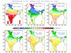 Similar to January, it has been warmer than normal in south and central India while north India has experienced cooler temperatures in the month of February[/caption]The actual rainfall in pan India so far in the period from January 1 to February 11 stands at 15.1 mm against the normal of 24.6 mm; the departure from normal currently stands at -39 per cent, having increased by 1 per cent week over week.Subdivision-wise winter seasonal rainfall till February 11, 2024:• Southern peninsula: Actual 18.5 mm against the average of 10.5 mm, +76 per cent departure from normal.• East and northeast India: Actual 16.6 mm against the average of 26.6 mm, -39 per cent departure from normal.• Northwest India: Actual 22.2 mm against the average of 48.4 mm, -54 per cent departure from normal.• Central India: Actual 6.0 mm against the average of 10.2 mm, -42 per cent departure from normal.[caption id="attachment_13717542" align="alignnone" width="214"]
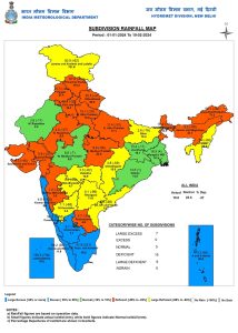 Subdivision-wise seasonal rainfall in India from February 1 to 10, 2024[/caption]Current synoptic weather features influencing weather in India as on February 12, 2024:
- A fresh western disturbance as a trough in mid-tropospheric westerlies with its axis at 5.8 km above mean sea level runs roughly along Long. 55°E to the north of Lat. 25°N.
- The cyclonic circulation over the south Gujarat region and neighbourhood at 1.5 km above mean sea level persists.
- The trough from South Interior Karnataka to west Vidarbha across North Interior Karnataka and Marathwada at 0.9 km above mean sea level persists.
- The cyclonic circulation over south Assam at 3.1 km above mean sea level persists.
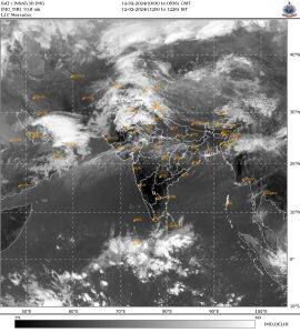 Satellite imagery indicating a fresh, weak western disturbance over north India on February 12; cloudy weather in some parts of east India due to wind instability[/caption]In El Nino years, western disturbances are very common during spring and early summer, which cause hailstorms and bring in plenty of damage to standing rabi crops. Similarly, this season, above-normal precipitation is predicted in the second half of February into March, and a new series of active western disturbances will start affecting the Himalayas and plains of north India from February 19 onwards. A fresh spell of wet and cool weather will begin once again.The writer, better known as the Rohtak Weatherman, interprets and explains complex weather patterns. His impact-based forecasts @navdeepdahiya55 are very popular in north India. Views expressed in the above piece are personal and solely those of the author. They do not necessarily reflect Firstpost’s views. Read all the Latest News, Trending News, Cricket News, Bollywood News,India News and Entertainment News here. Follow us on Facebook, Twitter and Instagram.
First Published:Feb 12, 2024, 15:06:59 IST
Advertisement
Advertisement

When Manila and Tokyo draw a line, Beijing draws a red line
What should have been a routine maritime-boundary negotiation between Japan and the Philippines has become a contest over China’s power to veto its neighbours’ strategic choices
6 min read
Bangladesh gets a new envoy to reset its India ties
The selection of a serving foreign secretary underscores the seriousness with which Dhaka now views its relationship with New Delhi
3 min read
Escalation trap to an exit strategy: How can the Iran war end?
This war is no longer about outright victory; it is about finding an exit without appearing to lose
7 min read
India must seize its demographic dividend before it fades
Adequate funding for universal education, leak-proof exams and job creation are vital to leverage India's demographic dividend before it’s too late
4 min read
Bangladesh’s instability has sharpened India’s ‘Chicken Neck’ challenge
India could consider notifying a union territory around the Siliguri Corridor consisting of parts of all bordering districts
8 min read
Advertisement
Advertisement