


The Weather Report: Monsoon to cover entire India this week as low pressure area builds up in Bay of Bengal
Despite a sluggish start of monsoon, pan India is expected to close the month on a normal note

The remnant of Cyclone Biporjoy as a low pressure area survived over Indian land mass near south west Uttar Pradesh for quite long, resulting in some heavy pre-monsoon showers in Uttar Pradesh, Madhya Pradesh, Rajasthan and even up to Delhi NCR and western Himalayas.
The monsoon was delayed this year hence most states of east India baked in extreme heatwave conditions for prolonged time in Uttar Pradesh, Bihar, Jharkhand, Odisha, Chhattisgarh claiming multiple lives in the state of Bihar, Uttar Pradesh and Jharkhand as per reports.
As a relief later in the week monsoon has picked up pace and drenched entire east India with good precipitation and brought down the temperatures from nearly mid-40°C to mid-30°C, a significant drop in temperatures and widespread rainfall has been a blessing for the farmer in the rice bowl of the country those were waiting for the seasonal showers to start sowing the kharif in the fields.
 More from Opinion
The subdued rainfall over the west coast and parts of southern peninsula has been a matter of concern too as the rainfall deficiency numbers are huge and the recovery would not be easy, as a low pressure area formed up in the Bay of Bengal recently it has also created a pull effect over the Arabian sea resulting in the strengthen of offshore trough at the west coast around 24 June giving a fair chance to the monsoon to revive over the drylands of western ghats and coast.
While the monsoons continued to play hide and seek for the rest of the country, north east India emerged to be the pure gainer and why not? Typical textbook moist southerlies from the Bay of Bengal have rushed towards the mighty Khasi hills lifting up and developing into nimbostratus clouds which can pour non-stop for days and weeks.
Heavy to very heavy rains continued to impact most parts of Meghalaya, Mizoram, Manipur, Nagaland, Assam, Arunachal Pradesh and Sikkim, the unprecedented rains also led to localised flooding in parts of Assam, remember it was just the first spell of monsoon rains.
Rare entry of monsoon in Delhi NCR and Mumbai on the same day: The monsoon finally arrived in Mumbai on 25 June, The onset date had tallied with the most delayed monsoon arrival for the city which was 25 June in 1959 and 2019.
As the trough stretches across north India given that monsoon has also advanced in Delhi NCR region and adjoining parts of Haryana, Chandigarh, Uttar Pradesh and western Himalayas also on 25 June, a very rare event as the progress of seasonal rains in both financial and national capital is observed after 62 years, the last time it matched was on 21 June 1961.
Mumbai and suburbs rainfall data from the onset spell ending 8:30AM on 25 June, 2023
Dahisar 217mm
Mira Road 183mm
Santacruz 176mm
Bandra 171mm
Palghar Agri 130mm
Colaba 86mm
Dahanu 65mm
Matheran 143mm
Mahabaleshwar 108mm
Harnai 137mm
Ratnagiri 106mm
Rainfall ending 8:30AM on 25 June from the monsoon onset spell in Delhi NCR and suburbs
New Delhi Safdarjung 48mm
Sonipat 111mm
Panipat 90mm
Dhansa Delhi 85mm
Gurgaon 82mm
Faridabad 74mm
Mahendragarh 80mm
Rohtak 46.6mm
In Shimla, the IMD recorded 99mm rainfall during the last 24hrs till 8:30am on 24 June and this is the highest single day rainfall in the capital of Himachal Pradesh after 2008 for the month of June. However, the highest record is of 123.7mm from 28 June 2008.
In the meanwhile Kangra Airport broke the single day highest rainfall record by experiencing 143.5mm in the span of 24 hours ending 8:30AM on 24 June.
Rainfall in span of 24 hours ending 8:30am on 24 June with the monsoon onset spell in Himachal Pradesh:
Kataula 163.3mm
Sihunta 160.0mm
Kasauli 145.0mm
Kangra Airport 143.5mm
Kangra city AWS 115.7mm
Bijahi 115.0mm
Shimla city 99.2mm
Kheri 82.0mm
Gohar 81.0mm
Sangraha 80.0mm
Shimla Airport 76.5mm
Pandoh 74.0mm
Sundernagar 70.0mm
Monsoon continues to move west and Amirtsar in Punjab experienced very heavy rains on Sunday night recorded 102mm till 5:30am on 26th June. Amritsar total rainfall in June 2023 now stands at 277mm , which is the highest ever monthly total breaking the previous record of 253.3mm from June 1996.
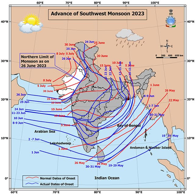
Latest on advancement of south west Monsoon as on 26 June, 2023:
• The Southwest Monsoon has further advanced into some more parts of north Arabian Sea, some more parts of Gujarat, Rajasthan, Haryana and Punjab, remaining parts of Jammu, Kashmir and Ladakh, today, the 26 June.\
• The Northern Limit of Monsoon (NLM) now passes through Lat. 22.0°N/ Long. 55°E, Lat. 22.0°N/Long. 60°E, Lat. 22.0°N/ Long. 65°E, Porbandar, Ahmedabad, Udaipur, Narnaul, Firozpur and Lat. 32.5°N/ Long. 72.5°E.
• Conditions are favourable for further advance of Southwest Monsoon into some more parts of Gujarat, Rajasthan, remaining parts of Haryana and Punjab during next two days.
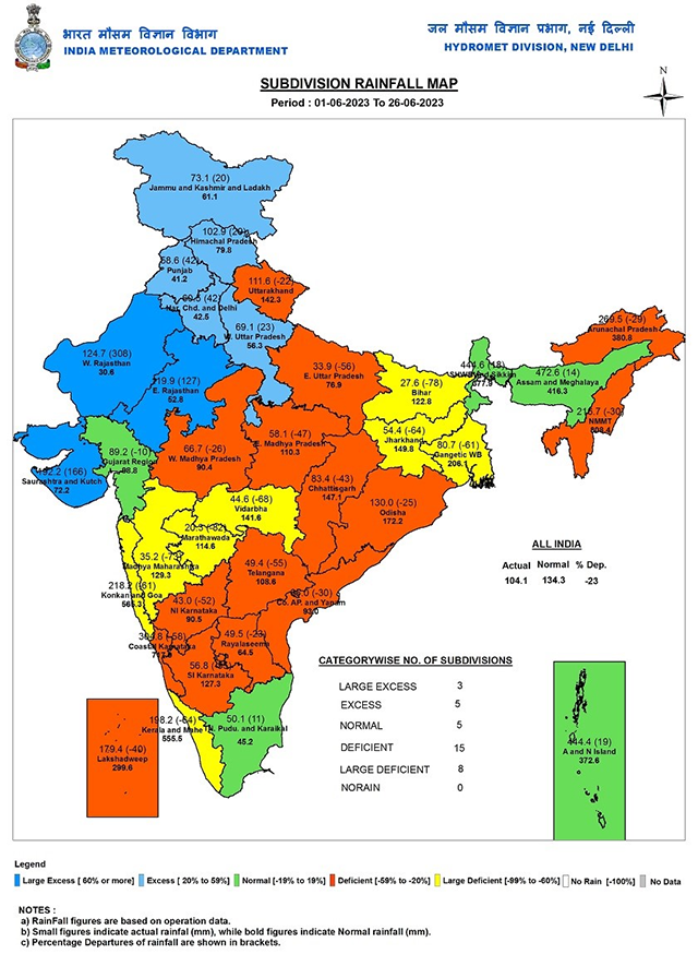
As the monsoon onset picked up pace and slight improvement is seen in seasonal rainfall statistics as well, till 26 June, India as a whole has received 104.1mm rainfall against the normal of 134.3mm, departure from normal stands at -23 per cent compared to week on week of -37 per cent.
Subdivision wise seasonal rainfall till 25 June, 2023:
• Southern Peninsula: Actual 73.5mm against the average of 137.2mm, -46 per cent departure from normal.
• East and North East India: Actual 211.2mm against the average of 274.2mm, -23 per cent departure from normal.
• North West India: Actual 86.1mm against the average of 59.1mm, +46 per cent departure from normal.
• Central India: Actual 87.6mm against the average of 134.9mm, -35 per cent departure from normal.
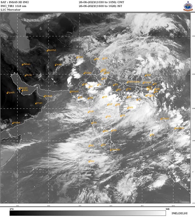
Current synoptic weather features influencing weather in India as on 26 June, 2023:
• The Low Pressure Area over north Odisha & neighbourhood now lies over north interior Odisha and adjoining south Jharkhand & north Chhattisgarh. Associated cyclonic circulation extends upto 7.6 km above mean sea level. It is very likely to move towards north Madhya Pradesh during the next two days.
• The east-west trough now runs from northwest Rajasthan to Northeast Bay of Bengal across south Haryana, south Uttar Pradesh, northeast Madhya Pradesh, Low Pressure Area over north interior Odisha and adjoining south Jharkhand & north Chhattisgarh and extends upto 1.5 km above mean sea level.
• The cyclonic circulation over central parts of south Uttar Pradesh extending upto 1.5 km above mean sea level has merged with the above trough.
• The off-shore trough at mean sea level now runs from south Gujarat coast to Kerala coast.
• The cyclonic circulation over Northeast Arabian Sea & adjoining Gujarat coast between 3.1 km & 5.8 km above mean sea level persists.
All India weather forecast till 2nd July, 2023
As the low pressure area turns up in the Bay of Bengal and expected to move westwards through east and central India -- monsoon will storm across the country this week.
The first low pressure area of the season is expected to travel across Odisha, Chhattisgarh, Madhya Pradesh till 28 June and expected to move into southern Rajasthan or Gujarat later in the upcoming week, on its way it will bring widespread heavy rains in West Bengal, Jharkhand, Odisha Chhattisgarh, Andhra Pradesh, Telangana, Vidarbha during 26 to 27 June and over Uttar Pradesh, Madhya Pradesh, Punjab, Haryana, Delhi NCR, Uttarakhand, Himachal Pradesh, Jammu, Rajasthan and Gujarat during 26 to 30 June.
Until 1 July monsoon is expected to cover most parts of India except some of the regions in Thar desert of west Rajasthan and Kutch and Saurashtra in Gujarat.
As a synoptic feature whenever a low pressure area passes through Central India it lead to decrease in rainfall over southern states as well as north east India as the convergence and moisture pull stops in interiors of Tamil Nadu, Andhra Pradesh, Telangana a relatively dry week is ahead for these regions, also as the southerlies will slow down, the unprecedented rains in the north east India will reduce significantly.
Despite a sluggish start of monsoon, pan India is expected to close the month on a normal note, Central, West and northern states will end the month on an above normal to excess rainfall note while it may end on slightly below normal for north east and East India and large deficient for southern Peninsula.
The author, better known as the Rohtak Weatherman, interprets and explains complex weather patterns. His impact-based forecasts @navdeepdahiya55 are very popular in north India.
Read all the Latest News, Trending News, Cricket News, Bollywood News,
India News and Entertainment News here. Follow us on Facebook, Twitter and Instagram.

When Manila and Tokyo draw a line, Beijing draws a red line
Bangladesh gets a new envoy to reset its India ties
Escalation trap to an exit strategy: How can the Iran war end?
India must seize its demographic dividend before it fades
Bangladesh’s instability has sharpened India’s ‘Chicken Neck’ challenge