


A study brings The Great Barrier Reef to living rooms
The Catlin Seaview Survey will use high-tech underwater cameras to carry out one of the most intensive studies of the reef up to a depth of 100 metres, with the public watching every step via YouTube and other Google sites.

Singapore: Finding Nemo is about to get a lot easier with the launch of a scientific survey that will allow anyone with access to the internet to take a virtual tour of Australia's Great Barrier Reef.
The survey, which will use a variety of high-tech underwater cameras, will carry out one of the most intensive studies of the reef up to a depth of 100 metres (330 feet), with the public watching every step via YouTube and other Google sites.
"There are a whole series of ways of using the imagery and ultimately this is bridging a gap between science and public awareness," said Ove Hoegh-Guldberg, chief scientist of the Catlin Seaview Survey.
[caption id="attachment_222896" align="alignleft" width="380" caption="The survey will also use robotic cameras to survey depths between 30 metres and 100 metres.Reuters"]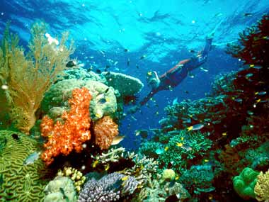 [/caption]
"The only way to do that is to make it part of people's activities," Hoegh-Guldberg of the University of Queensland said during the launch of the survey at a conference on the oceans in Singapore.
 More from News Analysis
The images will help better understand the impact of climate change on the reef and also help scientists carry out more regular surveys of fish, turtles and other animals.
A specifically developed camera attached to underwater vehicle will take thousands of 360-degree panoramic images from locations along the length of the 2,300 km (1,430 mile) reef off Queensland state.
These panoramas, when stitched together, will allow people to choose a location, dip underwater and go for a virtual dive.
Google's Panoramio site, which links pictures to locations, will eventually allow a total of about 50,000 panoramas to be uploaded and accessible via Google Earth and Google Maps.
The project will also have a dedicated Youtube channel.
"For the first time people will be able to explore thousands of environments along the length of the Great Barrier Reef from the comfort of their own home," cinematographer Richard Fitzpatrick told the conference during a live underwater interview from Green Island on the Great Barrier Reef.
Fishing and tourism along the reef earns Australia about $6 billion a year, Hoegh-Guldberg said, but scientists were still trying to figure out how rising sea temperatures and increased ocean acidity will affect the region over the long term.
The survey will also use robotic cameras to survey depths between 30 metres and 100 metres, a region scientists know little about, he said. This zone makes up 93 percent of the reef.
"So this becomes important in climate change because people have been suggesting those deeper areas may be protected from climate change and assist in the recovery of reef systems. But at the moment we don't know."
Reuters

Why AI notetakers are raising serious privacy and security concerns
China's low-cost AI models are changing the global AI race. Here's why Silicon Valley is worried
China's Kimi K3 challenges US AI leaders with frontier-level performance at lower cost
How did Instagram run ads promoting child abuse in India?
Why has India halted WhatsApp’s username feature before launch?