
Advertisement


Sections
Of Himalayan states, Assam, Mizoram, J&K least prepared for climate change hazards
Around 50 million Indians live in the Himalayan region & depend on its ecology for water, food and energy.

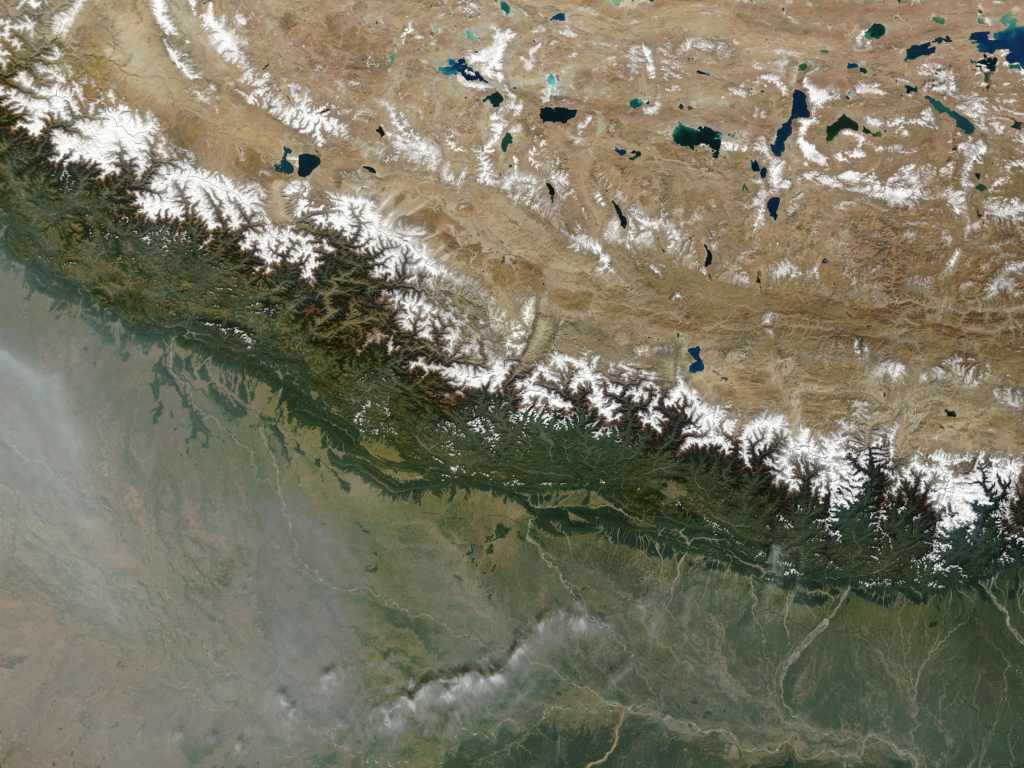
By Faizi Noor AhmadOf India’s 12 Himalayan states, Assam, Mizoram and Jammu and Kashmir (J&K) are the most vulnerable to climate change, a new study has concluded. High vulnerability leaves the region with low capacity to anticipate, resist, cope with or recover from the impact of a climate hazard.Himalayan communities are generally more vulnerable to climate change because they have fewer livelihood options, limited infrastructure and a high dependence on natural resources, the study said.Aimed at identifying the drivers of vulnerability and developing ways of adapting to and mitigating their impact, the study titled 'Climate Vulnerability Assessment for the Indian Himalayan Region Using a Common Framework' was conducted by the Indian Institutes of Technology (IIT) at Mandi and Guwahati and the Indian Institute of Science (IISc) at Bengaluru.The study was conducted in collaboration with the authorities in all the 12 states in the Indian Himalayan Region (IHR): Arunachal Pradesh, Assam, Himachal Pradesh, J&K, Manipur, Meghalaya, Mizoram, Nagaland, Sikkim, Tripura, Uttarakhand and West Bengal. Of these, West Bengal and Assam are only partially covered by the Himalayas.[caption id="attachment_6725801" align="alignnone" width="1024"]![The Himalayan range as seen from space. Image: NASA]() The Himalayan range as seen from space. Image: NASA[/caption]The vulnerability index is highest for Assam (0.72), Mizoram (0.71) and J&K (0.62), while Sikkim is the least vulnerable state with an index of 0.42. Sikkim’s advantage is only relative to other states, the study cautioned.Around 50 million Indian reside in the IHR and depend on the Himalayan ecology for water, food and energy. In these regions, glaciers feed up to 70 percent of agriculture. With climate change affecting the Himalayan landscape and weather patterns causing longer summers and shorter winters, the livelihoods and survival of these communities are threatened, IndiaSpend reported on 12 October 2018.A rise of at least 0.5 degrees C in the temperature has been recorded in the upper Himalayas, accompanied by an almost 10 percent variation in humidity levels. The temperature variation is causing the Himalayan glaciers, a part of the larger cryosphere — the part of the earth system that stores 75 percent of all frozen freshwater on earth — to melt. This has pushed up the odds of extreme events such as avalanches.[caption id="attachment_6032101" align="alignnone" width="1280"]
The Himalayan range as seen from space. Image: NASA[/caption]The vulnerability index is highest for Assam (0.72), Mizoram (0.71) and J&K (0.62), while Sikkim is the least vulnerable state with an index of 0.42. Sikkim’s advantage is only relative to other states, the study cautioned.Around 50 million Indian reside in the IHR and depend on the Himalayan ecology for water, food and energy. In these regions, glaciers feed up to 70 percent of agriculture. With climate change affecting the Himalayan landscape and weather patterns causing longer summers and shorter winters, the livelihoods and survival of these communities are threatened, IndiaSpend reported on 12 October 2018.A rise of at least 0.5 degrees C in the temperature has been recorded in the upper Himalayas, accompanied by an almost 10 percent variation in humidity levels. The temperature variation is causing the Himalayan glaciers, a part of the larger cryosphere — the part of the earth system that stores 75 percent of all frozen freshwater on earth — to melt. This has pushed up the odds of extreme events such as avalanches.[caption id="attachment_6032101" align="alignnone" width="1280"]![Image courtesy: High Himalayan]() Image courtesy: High Himalayan[/caption]The changing temperature pattern poses a threat to the water security and sustainability of the Himalayan river basins. With an increase in water flow in high-altitude lakes, the chances of floods also increase, IndiaSpend reported. In Himachal Pradesh, as per this 2013 study, farmers reported a decline in production and delayed harvest, blaming reduced snowfall. Nearly 80 percent of the farmers living at an altitude of 8,000 ft reported a noticeable decrease in snowfall and nearly 90 percent of those living at altitudes of 9,800 ft and higher said the same.India’s greenest and wettest Himalayan state, Meghalaya, is becoming warmer as rains there become more uncertain, leaving a quarter of its forests “highly vulnerable” to climate change, IndiaSpend reported on March 23, 2019, citing a 2018 study commissioned by the state government and carried out by the IISc. Its plant and animal life are being impacted, disturbing the lives of communities as well.
Image courtesy: High Himalayan[/caption]The changing temperature pattern poses a threat to the water security and sustainability of the Himalayan river basins. With an increase in water flow in high-altitude lakes, the chances of floods also increase, IndiaSpend reported. In Himachal Pradesh, as per this 2013 study, farmers reported a decline in production and delayed harvest, blaming reduced snowfall. Nearly 80 percent of the farmers living at an altitude of 8,000 ft reported a noticeable decrease in snowfall and nearly 90 percent of those living at altitudes of 9,800 ft and higher said the same.India’s greenest and wettest Himalayan state, Meghalaya, is becoming warmer as rains there become more uncertain, leaving a quarter of its forests “highly vulnerable” to climate change, IndiaSpend reported on March 23, 2019, citing a 2018 study commissioned by the state government and carried out by the IISc. Its plant and animal life are being impacted, disturbing the lives of communities as well. ![Indiaspend-logo]() The new climate change study is significant because it has produced India’s first vulnerability map. One of its aims is to evolve a common methodology, and determine how states and their districts are equipped to deal with the risks of climate change. A geospatial application has also been launched depicting climate vulnerabilities and risks at the state and district level.The research team has recommended similar vulnerability studies in other Indian states.
The new climate change study is significant because it has produced India’s first vulnerability map. One of its aims is to evolve a common methodology, and determine how states and their districts are equipped to deal with the risks of climate change. A geospatial application has also been launched depicting climate vulnerabilities and risks at the state and district level.The research team has recommended similar vulnerability studies in other Indian states.![]() Mizoram’s agriculture sector was found to be highly sensitive, with the second lowest percentage of area under irrigation among the 12 states. The state also has poor connectivity--its road density is the third lowest among the IHS--and poor access to information and infrastructure.J&K lags in road density, area under crop insurance, area under forests per 1,000 rural households, percentage of marginal farmers, percentage area under horticulture crops, livestock-to-human ratio, and percentage of women in the workforce.Himachal Pradesh, another vulnerable state, was found to have inadequate irrigation facilities — only 20-21 percent of its net cropped area is irrigated and the rest is mostly dependent on rains. But the low yield variability of food grains grown here reduces the sensitivity of agricultural production to climate change. The only drivers of vulnerability observed were low livestock-to-human ratio and a large presence of small and marginal farmers (who own less than two hectares of land), who constitute 87.95 percent of the total peasant population and own 54.17 percent of the total land.
Mizoram’s agriculture sector was found to be highly sensitive, with the second lowest percentage of area under irrigation among the 12 states. The state also has poor connectivity--its road density is the third lowest among the IHS--and poor access to information and infrastructure.J&K lags in road density, area under crop insurance, area under forests per 1,000 rural households, percentage of marginal farmers, percentage area under horticulture crops, livestock-to-human ratio, and percentage of women in the workforce.Himachal Pradesh, another vulnerable state, was found to have inadequate irrigation facilities — only 20-21 percent of its net cropped area is irrigated and the rest is mostly dependent on rains. But the low yield variability of food grains grown here reduces the sensitivity of agricultural production to climate change. The only drivers of vulnerability observed were low livestock-to-human ratio and a large presence of small and marginal farmers (who own less than two hectares of land), who constitute 87.95 percent of the total peasant population and own 54.17 percent of the total land.![Northern_Himalayas-1280]()
The author is an intern at IndiaSpend.
 The Himalayan range as seen from space. Image: NASA[/caption]The vulnerability index is highest for Assam (0.72), Mizoram (0.71) and J&K (0.62), while Sikkim is the least vulnerable state with an index of 0.42. Sikkim’s advantage is only relative to other states, the study cautioned.Around 50 million Indian reside in the IHR and depend on the Himalayan ecology for water, food and energy. In these regions, glaciers feed up to 70 percent of agriculture. With climate change affecting the Himalayan landscape and weather patterns causing longer summers and shorter winters, the livelihoods and survival of these communities are threatened, IndiaSpend reported on 12 October 2018.A rise of at least 0.5 degrees C in the temperature has been recorded in the upper Himalayas, accompanied by an almost 10 percent variation in humidity levels. The temperature variation is causing the Himalayan glaciers, a part of the larger cryosphere — the part of the earth system that stores 75 percent of all frozen freshwater on earth — to melt. This has pushed up the odds of extreme events such as avalanches.[caption id="attachment_6032101" align="alignnone" width="1280"]
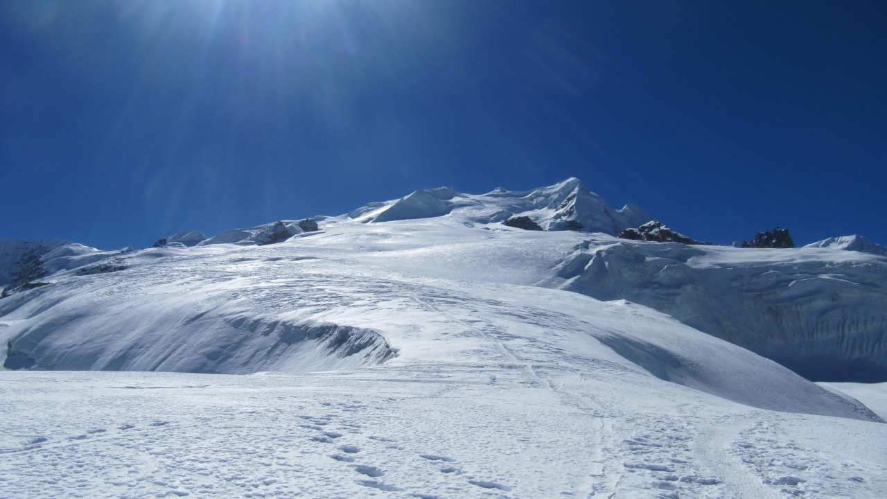 Image courtesy: High Himalayan[/caption]The changing temperature pattern poses a threat to the water security and sustainability of the Himalayan river basins. With an increase in water flow in high-altitude lakes, the chances of floods also increase, IndiaSpend reported. In Himachal Pradesh, as per this 2013 study, farmers reported a decline in production and delayed harvest, blaming reduced snowfall. Nearly 80 percent of the farmers living at an altitude of 8,000 ft reported a noticeable decrease in snowfall and nearly 90 percent of those living at altitudes of 9,800 ft and higher said the same.India’s greenest and wettest Himalayan state, Meghalaya, is becoming warmer as rains there become more uncertain, leaving a quarter of its forests “highly vulnerable” to climate change, IndiaSpend reported on March 23, 2019, citing a 2018 study commissioned by the state government and carried out by the IISc. Its plant and animal life are being impacted, disturbing the lives of communities as well.
  The new climate change study is significant because it has produced India’s first vulnerability map. One of its aims is to evolve a common methodology, and determine how states and their districts are equipped to deal with the risks of climate change. A geospatial application has also been launched depicting climate vulnerabilities and risks at the state and district level.The research team has recommended similar vulnerability studies in other Indian states.
Lack of information, infrastructure up the risk
The drivers of vulnerability vary across states. In Assam, the drivers include low per capita income, low percentage area under crop insurance and low participation in the Mahatma Gandhi National Rural Employment Scheme (MGNREGS), a poverty alleviation programme that promises 100 days of paid work to poor families. Lack of access to information and infrastructure are factors that make it difficult for communities in the state to cope with any climate variability. The western border district of Dhubri, the eastern district of Lakhimpur and the central district of Sonitpur are Assam’s most vulnerable.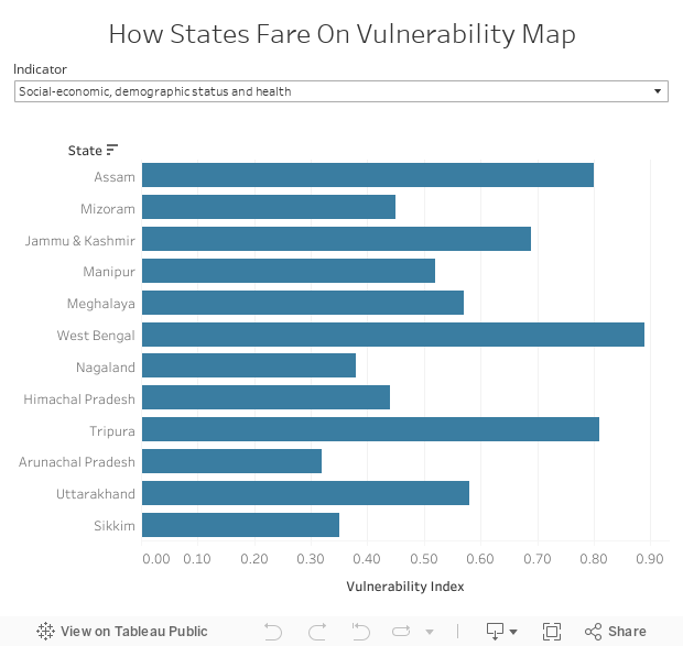 Mizoram’s agriculture sector was found to be highly sensitive, with the second lowest percentage of area under irrigation among the 12 states. The state also has poor connectivity--its road density is the third lowest among the IHS--and poor access to information and infrastructure.J&K lags in road density, area under crop insurance, area under forests per 1,000 rural households, percentage of marginal farmers, percentage area under horticulture crops, livestock-to-human ratio, and percentage of women in the workforce.Himachal Pradesh, another vulnerable state, was found to have inadequate irrigation facilities — only 20-21 percent of its net cropped area is irrigated and the rest is mostly dependent on rains. But the low yield variability of food grains grown here reduces the sensitivity of agricultural production to climate change. The only drivers of vulnerability observed were low livestock-to-human ratio and a large presence of small and marginal farmers (who own less than two hectares of land), who constitute 87.95 percent of the total peasant population and own 54.17 percent of the total land.
Vulnerability assessment, the first step to adapting
The first step in adapting to future climate change is to reduce vulnerability, as the Intergovernmental Panel on Climate Change suggested in its summary for policymakers, which the current report references."Vulnerability refers to the inherent characteristic — both biophysical and socioeconomic--of a system. The current assessment helps in identification of the major drivers of vulnerability, both at state as well as the district level, for the 12 Indian Himalayan states," said Shyamasree Dasgupta, co-principal investigator of the study and an assistant professor at the School of Humanities and Social Sciences at IIT, Mandi.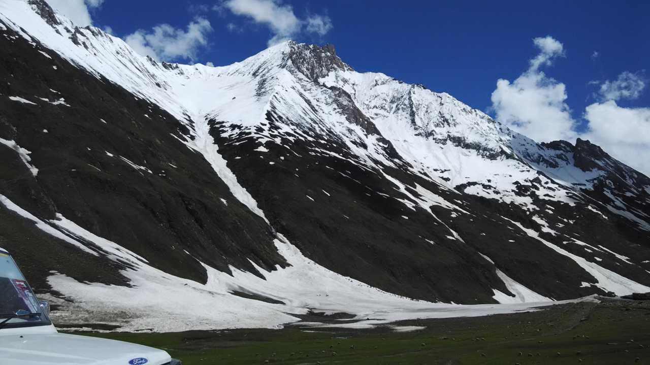
How India is dealing with the potential crisis
"The government institutions are likely to find the report useful," said Dasgupta. "Principal secretaries of some of the states (both Himalayan and non-Himalayan) were present during the dissemination workshop. However, it would be better to consider this study in the context of the assessment of climate vulnerability and climate change adaptation rather than disaster management."The central government is already implementing the National Mission for Sustaining the Himalayan Ecosystem (NMSHE) under the National Action Plan on Climate Change (NAPCC) introduced in June 2008. Climate change cells have been set up in 11 Himalayan states to undertake studies on climate change risk and vulnerability assessment.The government also launched a National Adaptation Fund on Climate Change (NAFCC) in 2015-16 to assist states and union territories with projects and actions. Some 26 projects had been approved across India at a total cost of Rs 648.9 crore, Lok Sabha data from 9 March 2018, said.| State | Project Sanctioned | Amount Sanctioned (Rs crore) | Vulnerability Drivers |
| Assam | Management of ecosystem of Kaziranga National Park by creating a climate-resilient livelihood for vulnerable communities through organic farming and pond-based fish farming | 12 | Least area under irrigation, least forest area available per 1,000 rural households, least number of farmers taking loans as compared to other states. It also has the second lowest per capita income, low percentage area covered under crop insurance and low MGNREGA participation |
| Mizoram | Sustainable agriculture development through expansion, enhancement, and modeling | 5 | Highest yield variability, no area under crop insurance, largest area under open forests, largest area under slope as compared to other states, second lowest percentage area under irrigation and third lowest road density among the 12 states |
| Jammu & Kashmir | Climate-resilient sustainable agriculture in rain-fed farming areas | 11 | Least road density, no area under crop insurance, low area under forests per 1,000 rural households, high percentage of marginal farmers, low percentage area under horticulture, low livestock-to-human ratio and low percentage of women in the workforce |
| Manipur | Development of model carbon-positive eco-village of Phayeng | 5 | Lowest per capita income, low percentage of farmers taking loans and low area under forests per 1,000 households |
| Meghalaya | Spring-shed development for rejuvenation of springs for climate-resilient development in water-stressed areas | 11.45 | Very less area under crop insurance, low per capita income, low area under forests per 1,000 households and low percentage of farmers taking loans |
| West Bengal | Rainwater harvesting and sustainable water supply to the hilly areas in Darjeeling, adaptive measures | 11.56 | Highest population density, least number of primary healthcare centres per 100,000 households, least percentage of women in the workforce, second lowest area under forests, high percentage of marginal farmers and low MGNREGA participation |
| Nagaland | Gene pool conservation of indigenous rice varieties under the traditional, integrated rotational farming system (Jhum optimisation) for promoting livelihood and food security | 12.34 | No area under crop insurance, low percentage of farmers taking loans and low area under forests per 1,000 rural households |
| Himachal Pradesh | Sustainable livelihoods of agriculture-dependent rural communities in drought-prone districts | 10 | Low livestock-to-human ratio, inadequate irrigation, large proportion of small and marginal farmers |
| Tripura | NA | NA | Highest percentage of land under marginal farmers, low per capita income, low percentage area under forests and crop insurance |
| Arunachal Pradesh | NA | NA | Large area underslope >30%, low road density, least livestock-to-human ratio, lowest percentage of area under horticulture crops, least participation in MGNREGA, no croparea under insurance and low percentage of farmers taking loans |
| Uttarakhand | NA | NA | Low area under forests per 1,000 households |
| Sikkim | Addressing climate change vulnerability of water sector at gram panchayat level in drought-prone areas | 10 | Low area under forests per 1,000 households, low percentage area covered by insurance and low percentage of farmers taking loans |
First Published:May 30, 2019, 13:34:48 IST
Advertisement
Advertisement

Govt to set up fast-track courts for swift punishment in paper leak cases, says PM Modi amid CJP protests
Amid protests demanding accountability for the leak of medical entrance test Neet and other irregularities in the education system, Prime Minister Narendra Modi has announced that the government has decided to set up fast-track courts to ensure swift and stringent punishment for those involved in paper leaks.
3 min read
Sikkim tunnel collapse rescue resumes, death toll rises to 22
The death toll at the collapsed tunnel at Sikkim's Namchi district rose to 22 after nine more bodies were recovered overnight. At least 27 workers were trapped in a tunnel at an NHPC project after a sudden burst of suspected methane gas trapped within rock formations triggered an explosion.
2 min read
Delhi Police asks personnel to wear uniform: What the law says on cops in plainclothes during protests
The Delhi Police has instructed all its personnel to wear uniforms when they report for duty at Jantar Mantar for crowd control. This comes after outrage grew over videos of men in civilian clothes or without name tags hitting protesters in the Capital. Is it legal for the police to ditch uniforms during protests?
4 min read
No premium queues, 30-minute target: What changes for Indian passport applicants in UAE
Indian passport applicants in the UAE can now access passport, visa and attestation services through Alhind’s 16 centres, with no premium queues, a Dh19 service fee and a target of completing applications within 30 minutes
4 min read
CJP Protest in Delhi Live Updates: PM Modi announces fast-track courts for NEET paper leak cases
CJP Protest in Delhi Live Updates: Heavy security has been deployed at the Jantar Mantar in Delhi, where the Cockroach Janta Party (CJP) is continuing its protest demanding the resignation of Union Education Minister Dharmendra Pradhan over the recent paper leaks controversy
1 min read
Advertisement
Advertisement