
Advertisement


Sections
Massive project launched to map Earth's underwater mountains, craters, shipwrecks
The UN-backed project is urging countries to pool their maps of the ocean floor to build the map.

A $3 billion project to map the mysteries of the ocean by mapping the Earth's seafloor — its hidden mountains, craters and shipwrecks — will soon be underway.Less than 9 percent of the Earth's ocean floor has been mapped in high resolution — less than we know about some of the other worlds in our solar system, according to Project Seabed 2030's scientists."If you go to the deep water, to the deep sea, right up in the centre of the Indian Ocean or the Pacific Ocean, you actually could miss entire mountains," Geoffroy Lamarche, a team member of the project, told ABC.[caption id="attachment_6280851" align="alignnone" width="1280"]![A new project aims to map the entire ocean floor in just over a decade. Image: Flickr/NOAA]() A new project aims to map the entire ocean floor in just over a decade. Image: Flickr/NOAA[/caption]There have been past instances of nuclear submarines collided with undetected hills deep underwater at full speed. One such accident of the USS San Francisco in 2005 injured 98 and killed one, according to an ABC report. The submarine barely made a successful ascent to the surface.Much of Earth's surface — 71 percent of it — is covered in water. However, less than a fifth of the ocean seabed on the planet (18 percent) has been studied at all, of which only half was high-resolution imagery.The United Nations-backed Project Seabed 2030, started in 2017, is urging countries to pool their data maps of the ocean floor to create the map, which they intend to be a freely-accessible online resource for all."We think it's ambitious, but we don't think it's impossible. (It) obviously needs a lot of cooperation from different parties — individuals as well as private companies," Mao Hasebe, project coordinator at the Nippon Foundation — a Japanese philanthropic organisation supporting the initiative — told ABC.The biggest contributors to the mapping process so far have been Dutch energy prospector Fugro and deep-sea mapping firm Ocean Infinity. Both of them were involved in the hunt for Malaysian airline flgiht MH370 that disappeared mysteriously in 2014.The process of mapping will use high-tech, multibeam echosounders that transmit a fan of acoustic beams from a ship and pick up on pings returning from the ocean floor's various depth and topographies. This process creates data points that need to be processed into a map.[caption id="attachment_6280841" align="alignnone" width="1280"]
A new project aims to map the entire ocean floor in just over a decade. Image: Flickr/NOAA[/caption]There have been past instances of nuclear submarines collided with undetected hills deep underwater at full speed. One such accident of the USS San Francisco in 2005 injured 98 and killed one, according to an ABC report. The submarine barely made a successful ascent to the surface.Much of Earth's surface — 71 percent of it — is covered in water. However, less than a fifth of the ocean seabed on the planet (18 percent) has been studied at all, of which only half was high-resolution imagery.The United Nations-backed Project Seabed 2030, started in 2017, is urging countries to pool their data maps of the ocean floor to create the map, which they intend to be a freely-accessible online resource for all."We think it's ambitious, but we don't think it's impossible. (It) obviously needs a lot of cooperation from different parties — individuals as well as private companies," Mao Hasebe, project coordinator at the Nippon Foundation — a Japanese philanthropic organisation supporting the initiative — told ABC.The biggest contributors to the mapping process so far have been Dutch energy prospector Fugro and deep-sea mapping firm Ocean Infinity. Both of them were involved in the hunt for Malaysian airline flgiht MH370 that disappeared mysteriously in 2014.The process of mapping will use high-tech, multibeam echosounders that transmit a fan of acoustic beams from a ship and pick up on pings returning from the ocean floor's various depth and topographies. This process creates data points that need to be processed into a map.[caption id="attachment_6280841" align="alignnone" width="1280"]![Noroit seamount is in the Caribbean sea. Image: NOAA]() Noroit seamount is in the Caribbean sea. Image: NOAA[/caption]"With advanced sonar technology, it really is like seeing. We've come out of the era of being the blind man with the stick," Robert Larter, a marine geophysicist at the British Antarctic Survey, said. "We can survey much more efficiently — and, not only that, but in much greater detail."The ocean is a big place, after all, and the work of assimilating the map — painstaking. While some regions, the ocean off the coasts of Eastern United States, Japan, New Zealand and Ireland for instance, are well mapped. But the rest of the world is an oyster that the Seabed 2030 project will crack open.
Noroit seamount is in the Caribbean sea. Image: NOAA[/caption]"With advanced sonar technology, it really is like seeing. We've come out of the era of being the blind man with the stick," Robert Larter, a marine geophysicist at the British Antarctic Survey, said. "We can survey much more efficiently — and, not only that, but in much greater detail."The ocean is a big place, after all, and the work of assimilating the map — painstaking. While some regions, the ocean off the coasts of Eastern United States, Japan, New Zealand and Ireland for instance, are well mapped. But the rest of the world is an oyster that the Seabed 2030 project will crack open.
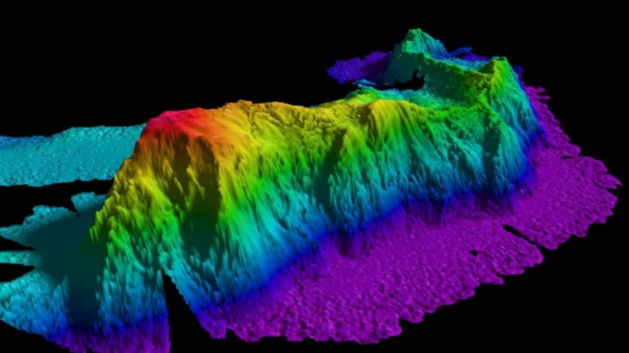 A new project aims to map the entire ocean floor in just over a decade. Image: Flickr/NOAA[/caption]There have been past instances of nuclear submarines collided with undetected hills deep underwater at full speed. One such accident of the USS San Francisco in 2005 injured 98 and killed one, according to an ABC report. The submarine barely made a successful ascent to the surface.Much of Earth's surface — 71 percent of it — is covered in water. However, less than a fifth of the ocean seabed on the planet (18 percent) has been studied at all, of which only half was high-resolution imagery.The United Nations-backed Project Seabed 2030, started in 2017, is urging countries to pool their data maps of the ocean floor to create the map, which they intend to be a freely-accessible online resource for all.
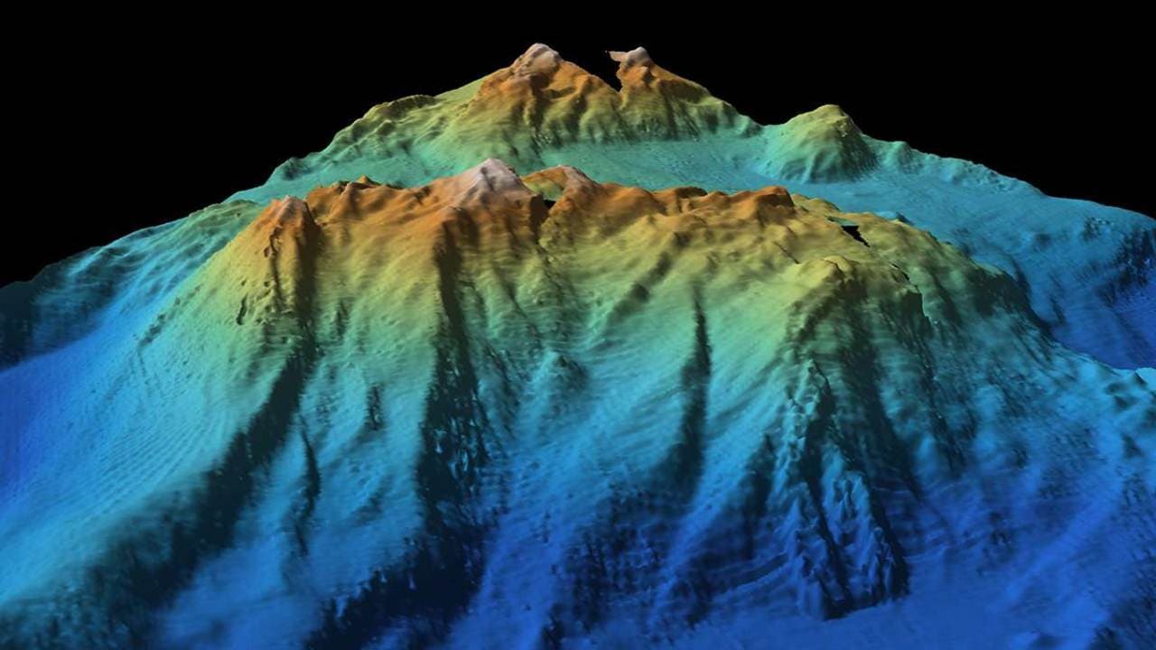 Noroit seamount is in the Caribbean sea. Image: NOAA[/caption]"With advanced sonar technology, it really is like seeing. We've come out of the era of being the blind man with the stick," Robert Larter, a marine geophysicist at the British Antarctic Survey, said. "We can survey much more efficiently — and, not only that, but in much greater detail."The ocean is a big place, after all, and the work of assimilating the map — painstaking. While some regions, the ocean off the coasts of Eastern United States, Japan, New Zealand and Ireland for instance, are well mapped. But the rest of the world is an oyster that the Seabed 2030 project will crack open.
First Published:Mar 18, 2019, 13:22:50 IST
Advertisement
Advertisement

Careless Whispers: Scientists discover that plants can 'talk' to each other using smells
Japanese scientists have recorded a video that shows plants, in certain conditions, communicate with each other using mists that carry smells. The discovery, reveals that plants release a fine mist of airborne compounds, to warn nearby plants of potential dangers
Life on Mars? European Space Agency’s Orbiter discovers ice water deposits at equator
European Space Agency's Mars Express Orbiter has identified massive ice and ice water deposits beneath the surface of Mars. The Mars Express orbiter was also the first to confirmed the presence of ice on Mars in 2004
Microsoft briefly overtakes Apple as the most valuable company, Apple back on top again
At its peak during the session, Microsoft's value reached $2.903 trillion, with a 2% surge. As of writing this article, Apple closed at $2.89 trillion, whereas Microsoft closed at $2.86 trillion
Even NASA is facing a tough time, starts layoffs following major budget cuts
NASA is facing some massive budget cuts, because of which, it has been forced to postpone some upcoming missions. NASA's Jet Propulsion Laboratory has been hit hard by recent federal budget cuts, resulting in the layoff of 100 contractors last week
ISRO, NASA's NISAR satellite to get ready by Jan-end, will monitor Earth's snow-covered regions
The NISAR satellite which has been developed jointly ISRO and NASA, should be ready for launch by the end of January 2024. The collaboration between NASA and ISRO on NISAR is the first time the two agencies have cooperated on hardware development for an Earth-observing mission
Advertisement
Advertisement